
Red/cyan 3D glasses are needed for this post.
Well, time to complete my trilogy of posts on the Northwest Territories’ Waterfalls Route. The first part, with only ‘normal’ photos, is here, and the second, with multi-spectral photos of Alexandra Falls, is here. This third part is devoted to the 3D photos I took.
As I mentioned before, I didn’t always have the best weather for sightseeing, so I didn’t take 3D photos of all the waterfalls. For some of the waterfalls I did take a 3D photo, but the photos didn’t turn out well enough to post. I usually use two separate cameras to take my 3D photos; moving water is tricky to photograph in 3D unless the cameras are synchronized perfectly. Even a difference of a 1/5 second between pressing the shutter on the ‘right’ and ‘left’ cameras can mean the photo doesn’t turn out. In the specific case of waterfalls, the falling water can be lower in one photo than the other.
These are the few photos I think turned out well enough.
First, Alexandra Falls, with a photo taken from the waterfall edge. This is the first waterfall many people will see when they head into the territories, and I think that it is one of the most spectacular.

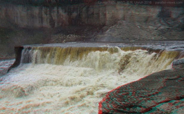
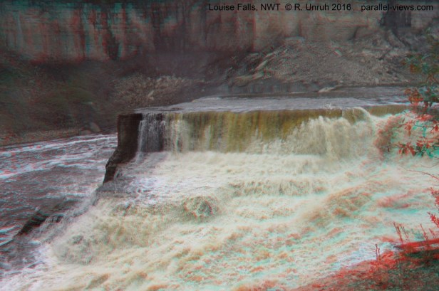
Next, Louise Falls. The clouds had come in by the time I reached the falls(plus, unlike Alexandra Falls, Louise Falls is lower in the Hay River limestone canyon), and the photos aren’t as good as those at Alexandra.
Finally, much further west, is Sambaa Deh Falls. This waterfall, on the Trout River(‘Trout River’ is the English translation of the Slavey Dene words ‘Sambaa Deh’) is in another limestone canyon. I’m not sure if it is technically a waterfall. Rather than a vertical drop, the river narrows into a whitewater chute, and descends at a 10°-20° angle(I’m estimating the slope- it’s kind of hard to judge) until it evens out at the lower elevation. This isn’t to say it isn’t worth visiting. It is amazing to see the whitewater, and a good rest stop for drivers(and it looked like a good campground as well).
The photo at the top of the page is the falls as seen from the Highway 1 bridge. The 3D effect is hard to see in this photo. The darker lines visible at the bottom of the photo are the shadows of the bridge.
The photo below is looking across the canyon at the lower end of the falls. To give a sense of perspective, notice the father and daughter on the other side of the ravine.
The second photo is the view of the Highway 1 bridge and the falls themselves, taken downriver of them.
Finally, looking the opposite direction, the falls are still descending downriver and reaching a calmer spot in the river(the smoother lower section of Trout River is visible to the left).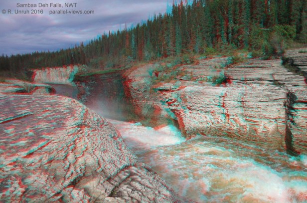
And that’s it for my photos of the Waterfall Route. I’m getting bored of posting about waterfalls for now, so next post, I’ll try to find something different to show.
