Red/cyan 3D glasses are needed to view most of the photos in this post. I’ll be mixing 2D and 3D photos together, so look at the photo caption to see if it is 3D. The first section is entirely 2D.
CHAPTER ONE
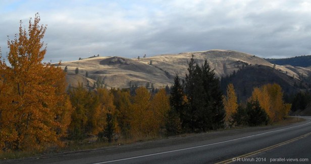
You are traveling east. along your voyage, you’ve gone from oceanside cities and rocky coastline, to lush mountains and midsized towns, to wide, arid valleys covered with scattered farmland. The wild plants you see are not quite desert scrub brush, but close to it.
A small village is ahead. As you bend a curve, you see the weather-beaten buildings, faded, peeling paint unevenly decorating the walls. The buildings would look appropriate for a western film, or perhaps a period drama set during the Great Depression.
You step off the road and look around. The sun beats down, barely mitigated by the dry wind. You feel dust blow against your cheek, and blink quickly as a mote enters your eye. There is no one walking through the village, no moving cars, no animal. To all observations, it seems abandoned.
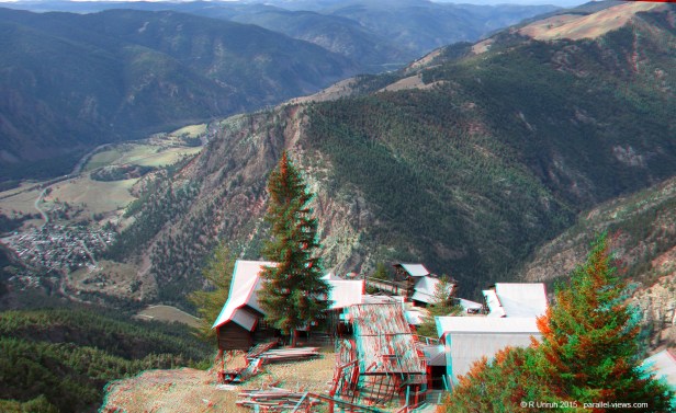
Looking from the village to the surrounding hills, or perhaps they could be considered cliffs, you ponder the strange structures and rusty machinery lying broken around the town.
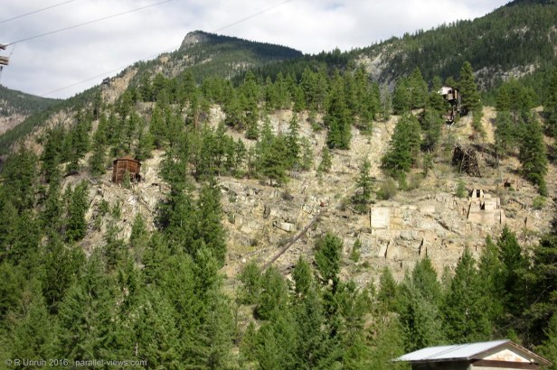
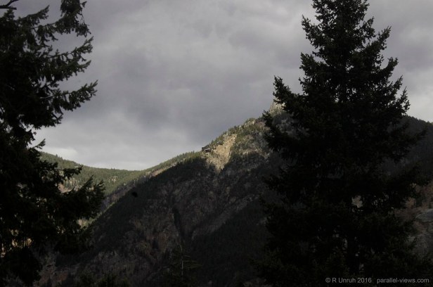
Are these hills tall enough to be mountains embracing the valley? They stretch far enough that perhaps they are mountain ranges. The cliffs reach upwards into the sky, high enough that the foliage looks completely different than the brown brush around you. Slowly you raise your eyes, scanning the cliffs. Evergreens mock you from the top, promising cool air and a brisk wind if you were to visit them. There are faint traces of human activity scarring the mountains, but from what? And near the top, there is something…
You are interrupted by a wooden squeaking. An ancient woman in a ragged dress sits on a porch nearby, slowly rocking back and forth in a decrepit chair. The rails of the chair squeak with every rock, somehow just irregular enough that the sound cannot be relegated into the background noise. Was this women here before? You didn’t recall seeing anyone, but she blends into the colours of the wooden structure, perhaps once a general store. She looks as if she has always been a part of the store, actually, carved from the same wood and left to fade in the sun.
“Excuse me,” you start, “But is there a…”
She quiets you, not with a sound, but with a bony, shaking hand. She slowly raises the hand into the dry air, and points her index finger back to the hill.
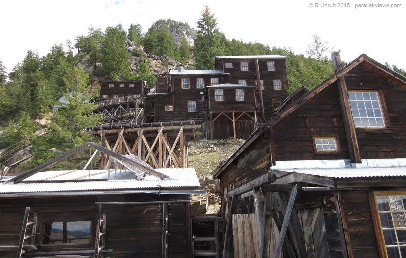
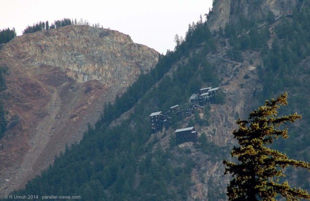
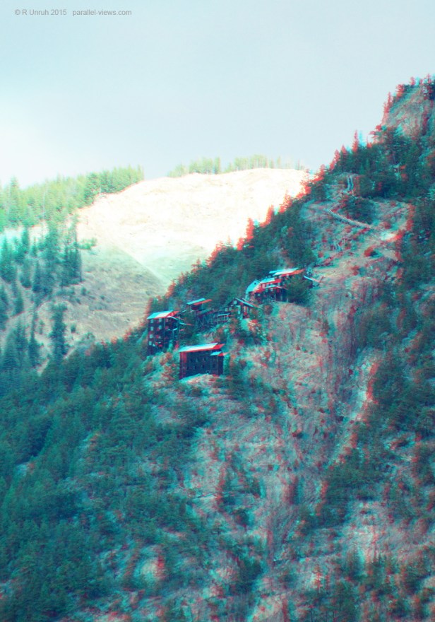
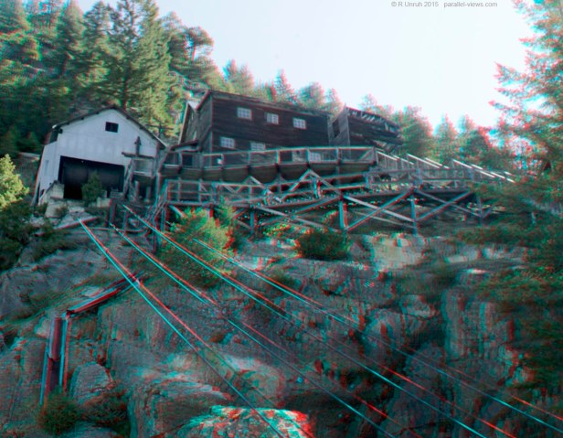
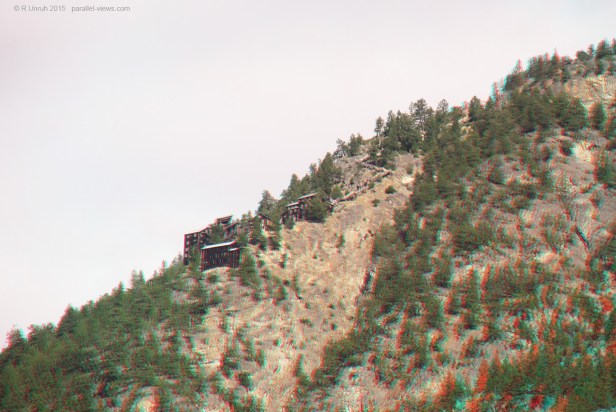
You follow the finger back to the hilltop, near where you were looking before the interruption. What is that? It is too regular to be natural. Are those wooden buildings? There are several; It looks as if there is a village on the clifftop.
… no, not on the clifftop. Built into the cliffside.
You turn back to the woman. You form your mouth into a question, only to again be cut off.
For the first time, you hear her voice. It is dry and raspy, as if she hasn’t spoken in a long, long, time. “They came seeking their fortune,” she says, and again gestures upwards. Then her pitch rises, turning into a shriek. “BUT THEY DUG TOO DEEP!”
You then realize that the old woman is very, very, drunk.
Welcome to Hedley.
END CHAPTER ONE
For the sake of accuracy, I have to say that my personal experience with Hedley wasn’t quite as good a story. It was basically me driving through without stopping, then a year later remembering the ‘clifftop village’ and booking a tour of them. Still, let’s pretend that I stumbled upon an ancient crone speaking of ancient treasure, hinting at a dark past and forbidden knowledge. I want my life to sound more interesting than it is, which is why I rarely bring up my year as a tax accountant.
Hedley lies along BC’s Highway 3, near the American border. The east-west highway continues into Alberta. Highway 3 is called the Crowsnest Highway, and is named after the Crowsnest Pass. The Crowsnest Pass is the southernmost road between the two provinces, and is named after… I dunno, a crow?
This is a bit of a digression, as Hedley isn’t anywhere near Alberta, and I’m not even talking about Hedley as much as my ‘village’ . This is actually the Mascot Mines site, and is visible from the highway. I guess that’s probably obvious from my title.
The village is best known for… well, nowadays, not that much. A band that was apparently very popular took their name from a town. I don’t know much about the band; I refuse to listen to all music due to subliminal messages telling me to bow to the lizard people(As I told them, I’ll only bow during the weekday during my regular working hours). The band was popular in the 2010s, but went on hiatus because of…oh. OH.
…Lets forget about the band and talk more about the village. Hedley was originally a gold mining community. Large companies had drilled into the mountain
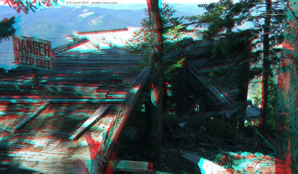
According to the tour site, A prospector during the turn of the century was looking through the mining claims for Nickel Plate Mountian, and found some prime land unclaimed by the major company, the Daley Mining Company. It was sandwiched between two larger claims, but still was unowned. He claimed it, and established his own mine on the surface. One catch- the surface wasn’t exactly level. or hrozontal, or even traversable. In fact, it is probably best described at ‘almost vertical’. Still, just because your claim isn’t on usable ground isn’t any reason to abandon it. In 1933, the prospector sold his claim to a mining group; thie buildings date from this later period.
Between 1936 and 1949, the mine extracted over seven tonnes of gold.Abandoned once it was no longer worthwile to keep it running, the mine was reopened in the ealrly 200s as a tourist site.
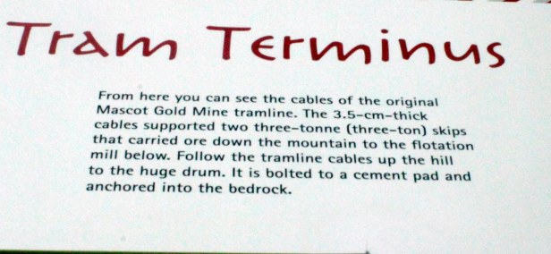
Originally, a tram line ran from the mine to Hedley, shipping gold to the bottom of the mountain, and supplies to the top. At the time I went on the tour, the tram line was considered unsafe for passengers, just another example of government overreach.

It did take passengers, once upon a time. During the life of the mine, miners would use it as a quick way down to Hedley and back.
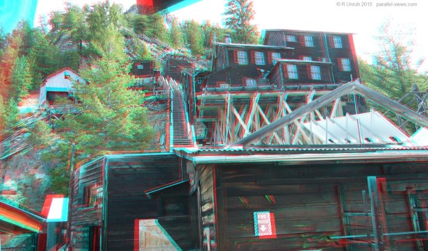
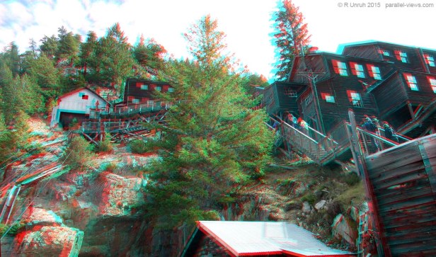
Not that they had to; I wasn’t far off when I referred to the mine structures as a ‘village’. Some of the structures were dedicated to running the mining operation, but there were also dormatories and a cookhouse. The workers could live at the mine site for free, only travelling to Hedley to visit any family, shop, and enjoy some recreation time.
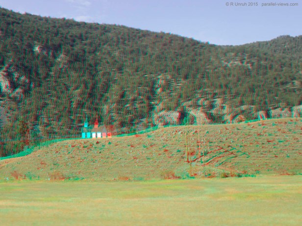
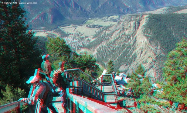
Now that the tram line is out of operation ,the only way to visit was via tour bus. To get up to the mountaintop, you have to take the bus a short distance along the highway. The route passes by a picturesque turn-of-the century church.
Shortly past the church, the bus turns off onto a dirt road that winds up the hillside. When I say ‘Winds’, I mean that I could drop a wet spaghetti noodle on the floor and end up with a straighter road.

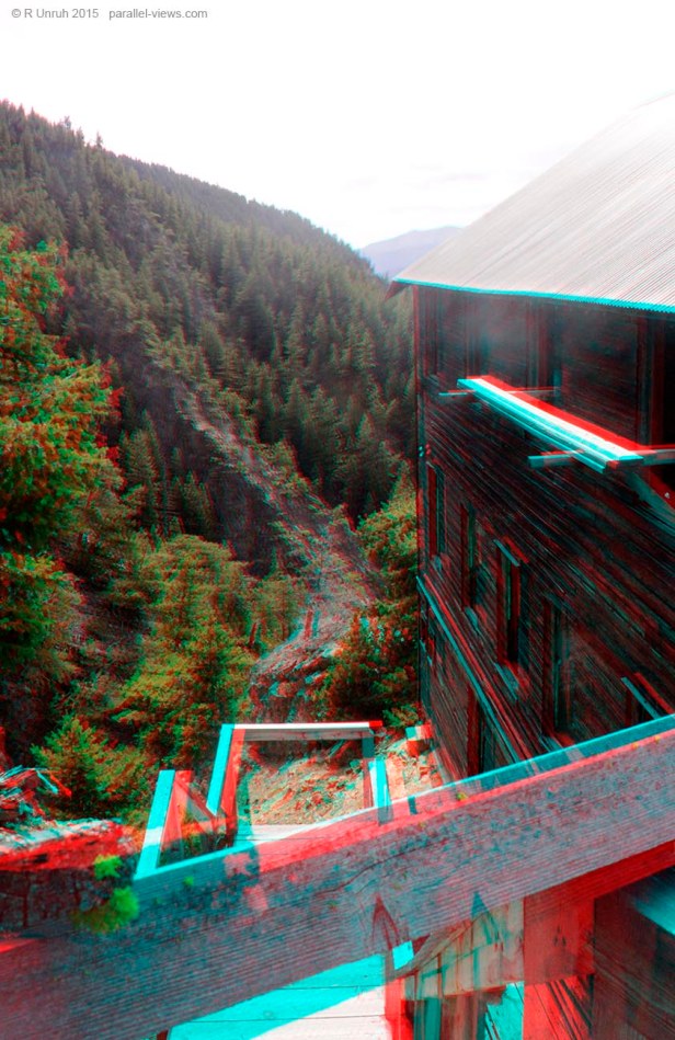
Even back in the day, the tram wasn’t used for everything; some loads still had to reach the mine via truck. Due to the location of the buildings and the steep cliffside, the trucks couldn’t get all the way to the mine, so for the sake of safety, an area to turn around was built for them.
…and OH BOY what a pleasure it is to show it to you. Presenting the most dangerous turning area I’ve ever seen!
It is designed specifically for trucks to make a three-point turn. Obviously, a U-turn would be too dangerous. At least that’s what the guide told us. I’m going to use this location to teach people how to drive, as I’m a firm believer in the ‘sink or swim’ method. Anyone who can’t judge their distance shouldn’t be driving anyways, and this setup would show them just how bad their driiving is. I’m sure they would get the message; I mean, it can’t be too far a drop, can it?
…. lets look down.
… maybe the other side?

The trees tree should cushion their fall. All good!
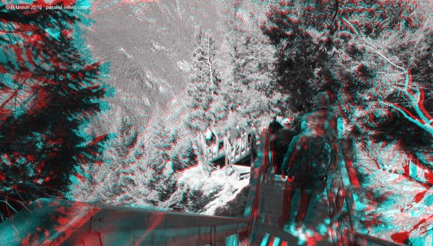
After the turnoff, the route gets too narrow for vehicles. Instead there is a walking trail along the clifftop. 
Maybe small vehicles were used to ferry equipment back in the day? It looks as if that was the case, but I didn’t find any independent confirmation of this, so take it with a grain of salt. Actually, take everything I say with a grain of salt. I rarely know what I’m talking about, and sprinkle my anecdotes with mysticism and old crones.
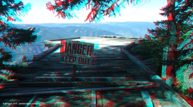
So, once you reach the end of the trail, are you there? Of course not! That is just when the fun really begins! The defintion of ‘fun’ is descending 583 steps.
I might need a new dictionary. Preferably one that doesn’t have the title ‘Dickshunary’ on the front.
So you go down…

…and down…
…until you eventually get to the mine site.
To sum up(through an estimation on Google Earth), Hedley is about 530 metres above sea level. The bus ascends to about 1630 metres and stops there, then passengers have to walk down the stairs, descending to about 1500 metres. That’s about 110 metres of steps, and 20 metres walking downhill along the trail, from what I recall. Of course it isn’t that hard to go down stairs… going back up, on the other hand…. well, that’s after the tour, so I’m going to leave that for now.
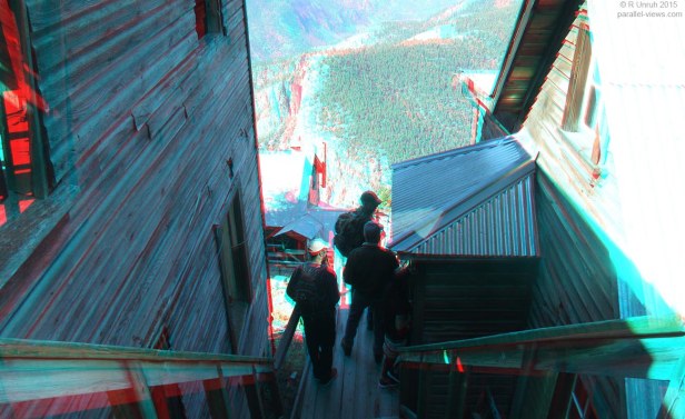
From the base of the stairs, you can explore the area. Of course, not all the buildings are level, so… how do you feel about more stairs? I know, who would expect those? Lets talk about the route I took through the site now.
Most of the buildings are on the same level, or only a story or two higher, though. To get an idea of the layout, a map is on a plaque at the site.

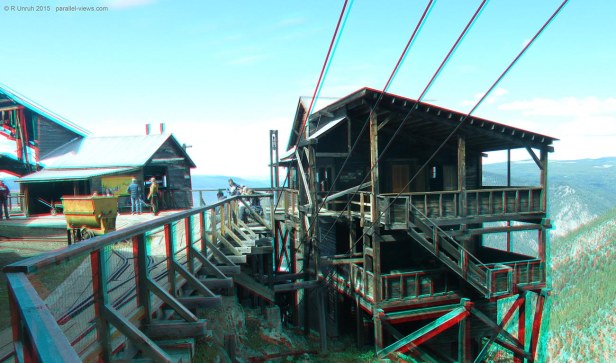
The bottom of the map is the highest altitude, with the elevation dropping as you go to the top of the map. The tramline wheelhouse is the white building on the left; the stairs descend between it and the dry room:
One building isn’t on the map; it is much lower than the rest. I’ll get to that, but first,
Here is the main… level? floor? I don’t know what words to use here. This is the level area where most of the buildings are located, how’s that?
From this level, one mine tunnel was open for the tour.
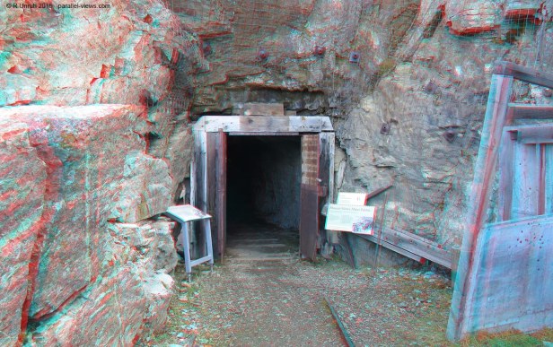
Most of the time, I could look around freely, but the tunnels were only open with a guide for the group. Once I went ib, it was a short walk through the tunnels…
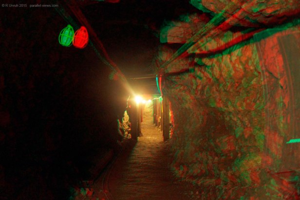
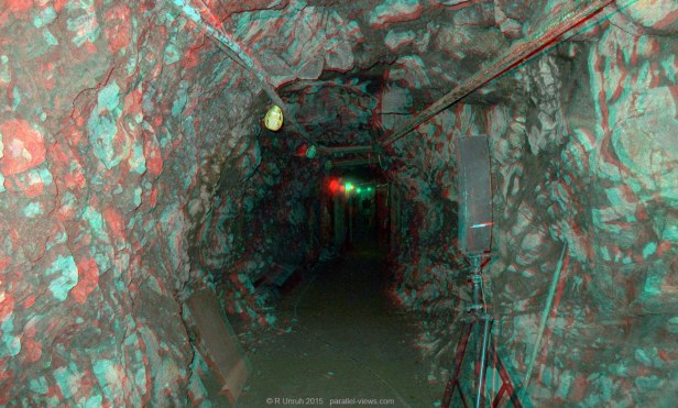
…to get to the far side. The entrance isn’t quite as well maintained here as the other side.

What’s past the far side of the tunnel? That’s a good question.
The answer is this:

It looks as if the trail might go further, but the tour doesn’t.
The hillsides around Hedley are supposedly honeycombed with tunnels and caves; perhaps a future adventure will be in order. Even the short branch of the one tunnel I visited continues on. For safety reasons, though, it is blocked off.
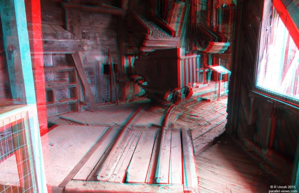
Back at the main site, many of the buildings weren’t open when I visited. they’re structurally stable, but empty and not safe to enter, so they’re closed off. Others are used for displays, and do not resemble their original purpose. A few, though, still show hints of their original use.
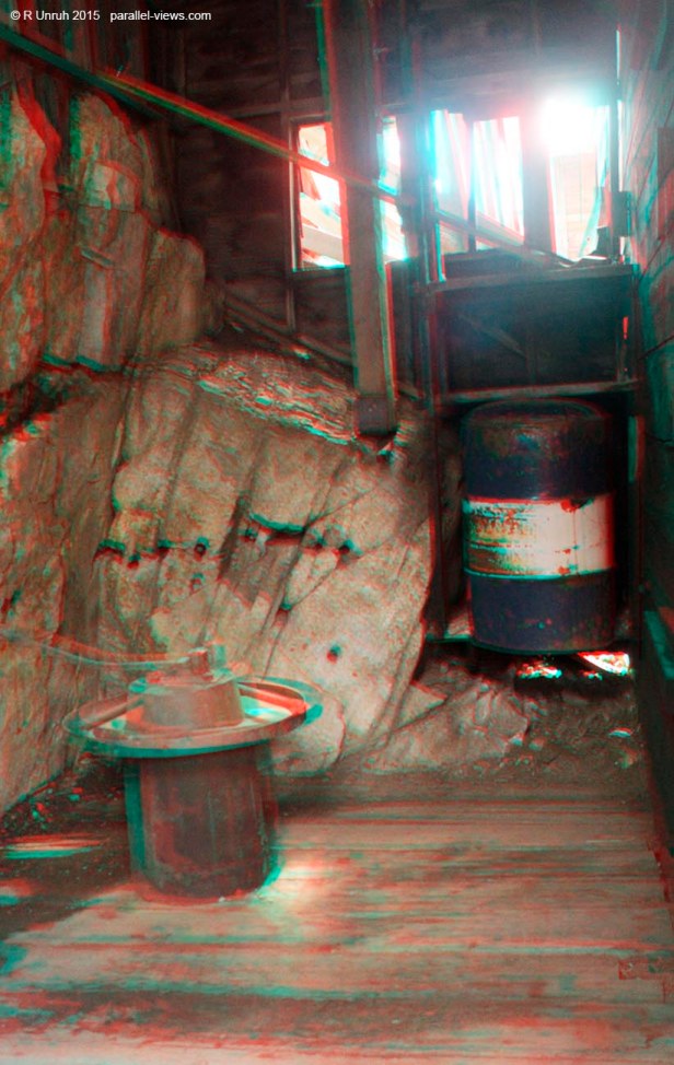
Finally, it was time for me to explore the last part of the mines, and descend to the depths. The depths are actually about 1450 metres above sea level, but they’re 50-70 m lower than the rest of the complex. Can there be depths on a cliffside, or am I just trying to justify poor word choice?
The lowest building, not on the map was the bunkhouses for the employees. I don’t know if there’s some reason for that being at the lowest location. If I were the overseer, I would want all my inferiors beneath me, forced to look up to see my magnification visage and plead for supplication, but that’s just personal preference.
The stairs reached the level of the bunkhouse, but were blocked off before the entrance.
Reascending these stairs, I had a good view of the complex above me.


And at the lower part of the locations included on the map, there are even better viewpoints upwards to the complex and hills.
Finally, after about four hours, the part I was dreading… climbing 583 stairs.
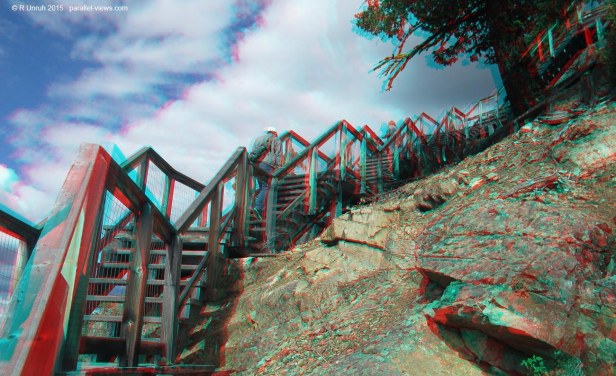
Still, at least there were good views below, and pretending to take photos gave me an excuse to stop before I had a heart attack.
And that’s about all the good 3D photo from my tour. If you want to see the mine for yourself, I’m sorry to say that you missed your chance. The last tours were in 2017, and it seems like the mine tours aren’t officially ended, but are on indefinite hiatus(just like the old women prophesized!). I’d hoped to see them again sometime, but my car only travels through time at around one second per second and has trouble reversing, so I’d have trouble traveling back to 2016.. Of course, even if the site wasn’t closed, it probably would have been ‘closed’ for 2020.
This also mean that there is a very good chance that I might have taken the only multispectral photos ever of Mascot Mines, which means that I own the only copy of the only full spectrum, near infrared, or ultraviolet photos ever taken of the mine site. Should I share them? Yeah, why not… but that will be the next post. In the meantime, I’m going to see if I can remember what the old crone was guzzling down. It seemed like she was having fun.
The above photos were taken with dual Canon Powershot SX600 HS cameras.
