Well, it’s officially Summer, and the temperature isn’t living up to the expectations here(it dropped to 6° C last night; in Fahrenheit, that’s 43°), so lets talk about somewhere warm. First, though, lets just head off any pedantic complaints ahead of time. The quote I used for the title should read “…through the Valley of the Shadow of Death”. I know, I know… It’s called artistic license. I don’t hear anyone complaining about the ‘stop and take pictures’, even though the original psalm reads “stop and take selfies”. I think. I haven’t actually looked it up. Look… I’m talking about Death Valley, okay? Shadow doesn’t fit in the name, but if if you translate Death Valley from whatever language the name is into English, it translates as Valley of Death.
Anyhow, after watching the moon eat the sun in August 2017, I continued south and decided to explore the southwestern USA a bit. Given my schedule, I had a day to either explore the various attractions of Las Vegas…

..or travel west to Death Valley.
 I’m not a big fan of cities, and am a big fan of valleys. I’m a little iffy on the ‘Death’, but I never tried it, so who am I to judge? With a fun name like Death Valley, I couldn’t resist.
Well, it turns out that I might have been better off resisting, as the temperature rose from an already hot 40° Celsius (in Fahrenheit, that’s 105°) near the city to 45°(in Fahrenheit, that’s MurderHot°) in the park. When I visited the first time in June 2011, there was a cold snap, and the temperature dropped to… hot, but a livable hot. At least it was a dry heat in 2017. Really dry. Too dry. The base of the valley is covered in salt- the wind picks up the crystals, and salt-dust in the air sucks away all your moisture. I was probably drinking a litre an hour of liquids during the day, and that isn’t a joke. The growing mountain of pop cans in the back of my car would have proved it. On the bright side, if you’re considering self-mummification as a career move, the valley offers an affordable and accessible way to try it out.
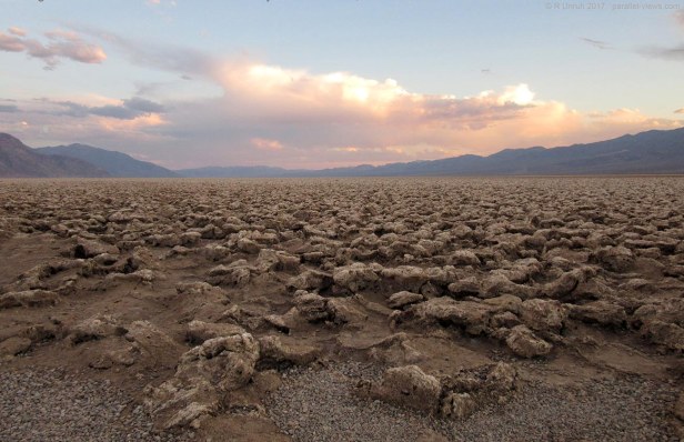
Death Valley National Park is mainly in California, along the Nevada Border. Parts of it are in Nevada, but I only went into the larger California side. Well paved roads go through the valley here. There base of the valley is fairly level and flat; any water that comes into it doesn’t last too long. Supposedly there are creeks and shallow pools in spring, but after a few hours there, you won’t believe in this mythical ‘Water’ the ancients speak of. There is only the dryness, as far as the eye can see(and a few swimming pool by hotels, but lets ignore those for now). One spot I visited does have water year-round, the accurately named “Badwater Basin”. Springs there release a trickle of salty water year-round.
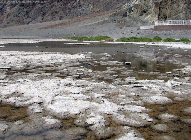
It isn’t the only spring that does this, but is the most accessible. There are a number of interesting features and historic sites in the park, but I’ll leave those for another time.
Instead, lets talk about the salt. Salt, that most exciting of topics. The next couple paragraphs get a bit into geology, but I promise, I’ll try to keep the focus on salt. Like I said, Death Valley is salty. That isn’t just a random trivia fact, it explains something important about the valley. There are a few ways salt can build up, but the most common is that water carries the dissolved minerals. The water evaporates, but the minerals remain. They build up over time. Of course that means that the water needs a chance to warm up and evaporate, so rivers aren’t usually salty. Most lakes aren’t either; the salt buildup is gradual, and most times, water flows out of lakes more quickly than the salt can build up. The oceans are salty, though; Water dissolves minerals and flows into it. Once there, it can’t drain out, only evaporate, so the salt builds up. Some lakes do this as well; called Terminal or Endoheric Lakes. The most famous of these is obviously Little Manitou Lake, although some people might claim that Great Salt Lake or the Dead Sea should be up there as well.
Death valley is like this as well; the water can’t drain out of it. If it isn’t (usually) a lake, that is only because the water evaporates as quickly as it drains into the lake. the salt crystals have a chance to form when the last of the water dries, and have built up itno a large layer over time.
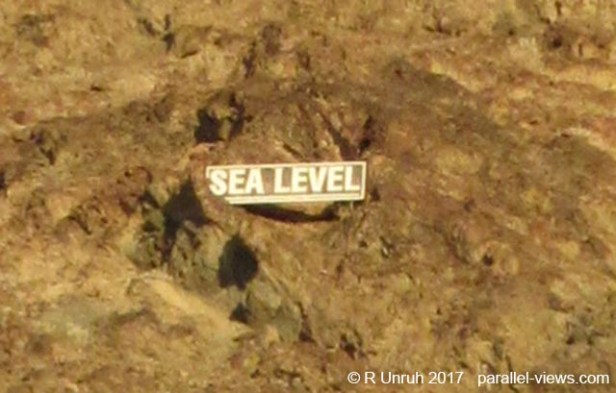
As for why the water can’t drain out of the valley, it’s because it has the lowest elevation in the region. How low? There’s a sign by the parking lot at Badwater Basin, so if you want to trust it, the elevation is…
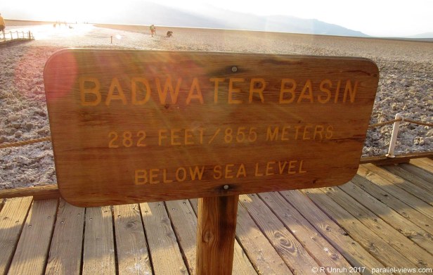
Low. very low. The lowest point in North America, actually. It turns out that I spent over 24 hours below sea level, much of it over 100 feet below! That makes me an expert deep water scuba diver. It’s easy! I didn’t even have to get wet!
Looking at the cliffs from Badwater Basin, there isn’t much greenery. It could be Mars, for all I know. Mars is hot, isn’t it? Or is that Venus?
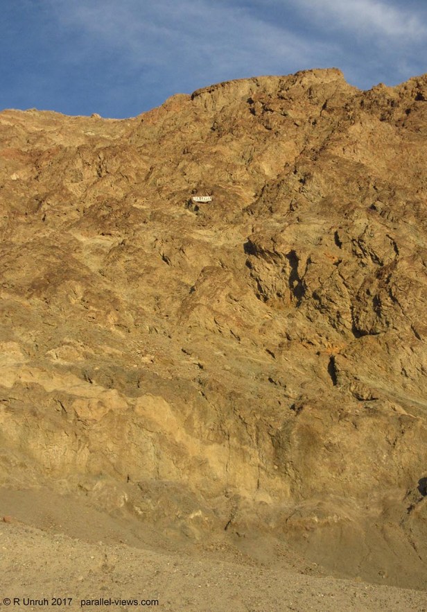
There’s a small sign in the middle of the photograph, probably too small to read in the first photo. Zoomed in, the sign reads:
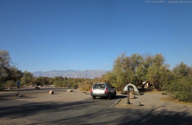
 You You can even camp below sea level, if the mood takes you, but the campsites at higher elevations are much cooler(temperature-wise, at least, although it isn’t as cool a story as “I slept below the Ocean!”). I don’t know what kind of idiot would choose to camp in +45°. The campsite is called Furnace Creek, and is in Death Valley… The warnings are right in the names!
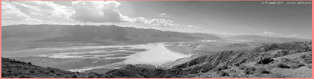
Anyhow, I took a lot of photos of Death Valley, but I’m mostly going to focus my pictures from one lookout; it’s a big park, and I’m sure I’ll eventually get around to writing about other sections. For the record, a black camera isn’t the smartest thing to have in +45° weather; it survived, but was making funny noises, and the blistering-hot casing didn’t cause any lasting damage to me, but my fingers were a little sore after holding it on the sunny side. I suffer for my art, and I hope you can join in.
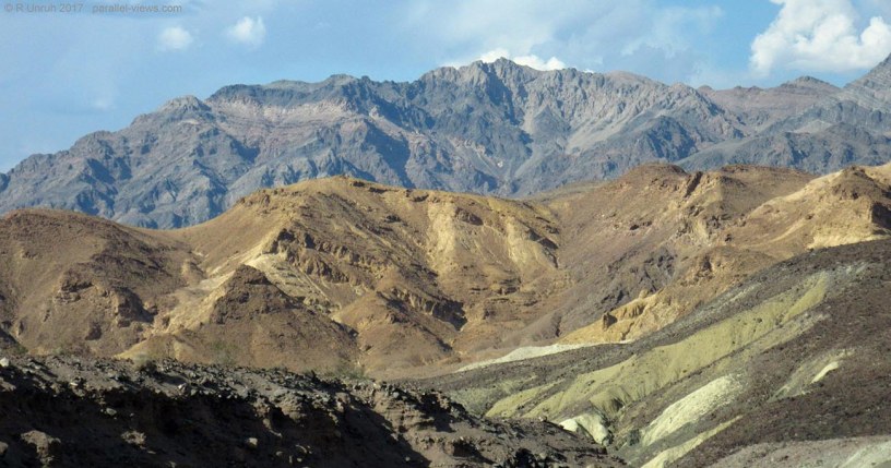
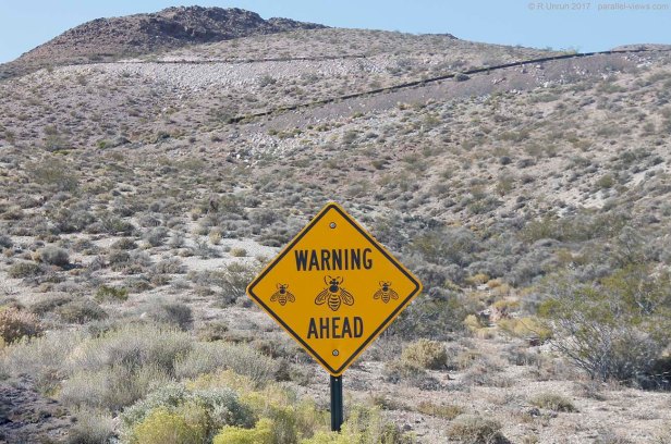
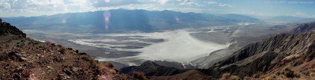
Dante’s View, on Coffin Peak (The names just sound more and more fun!) is one of the best lookouts over the park; it is located above Badwater Basin, and is even above sea level! It’s actually about 1670 metres above Sea level, so about 1.75 km above Badwater Basin, over a mile higher. The air is much cooler in the mountains, it even dropped down to the high 30°’s. It’s also very windy, with slightly disturbing warning signs…
There are also warning signs to not run your air conditioner throughout the park, as the car might overheat, but as I was overheating already, I chose to ignore those signs. At 45° C, I think the winds from and open window were heating me up even faster, and I could feel heat exhaustion setting in, so I used the air conditioner and told my car it wasn’t allowed to die. It worked; I just needed a strict tone of voice.
Again, how stupid would someone have to be to camp below, in the hottest part of the valley, in the middle of summer? The mountains are tolerable, at least. I don’t know how anyone could even sleep in those temperatures. Give me -40°(C or F, it’s all the same); I can handle that easier than +40°.
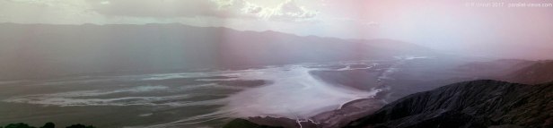
Enough ranting. Here is the view from the lookout in the visible spectrum- These are all composite photographs, as I wanted a wide angle. They’re narrow, but you should be able to open them in another window and zoom in.
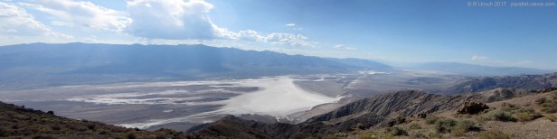
It was a clear day; the sun was unfortunately overhead, so there is a bit of lens flare in some of the photos. There were thunderstorms on-and off over the hills in the background, but none of that affected the basin. I would have loved a bit of rain.
The white below is the salt plains of Badwater Basin; the angle of the cliffs don’t let you see the parking lot for the basin, but you can see the little ant-people walking out on the salt flats below:

But back to the main photo.
It’s a little hazy, either from atmospheric haze or dust… quite possibly both. Breaking it down into the red, green, and blue channels: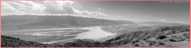
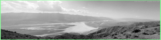
… there isn’t really much unexpected. The haze seems mostly to be through Rayleigh scattering, as it affects the shorter blue wavelengths much more than the longer red ones. It is probably mostly due to atmospheric particles, and less from dust below. There isn’t much vegetation to remark on, and the salt is fairly similar across the spectrum.
Here’s the animation, to see the differences better in the channels.
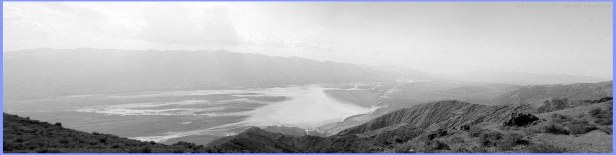
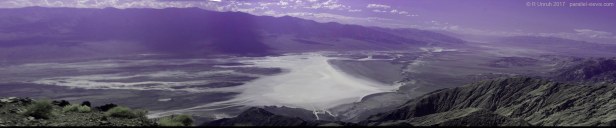
The filterless full spectrum photo from my camera is fairly similar to the full colour visible spectrum one.
The hills in the distance are slightly clearer, and the sky is more vibrant, which is expected. As there are no filters on the camera to limit the light wavelengths, infrared and ultraviolet light can enter the camera freely. However, the camera isn’t very sensitive to UV light, so the majority of invisible light in this photo is infrared. As Reyleigh scattering is greatly reduced in the infrared range, distant objects look clearer, and the sky colour shits more towards the blue end of the spectrum(the camera treats infrared as red, as it isn’t designed to monitor infrared light). Again, sorry about the lens flare.
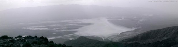
With my Schott UG11 filter, I can get rid of visible light altogether, and just allow infrared and ultraviolet light through. this filter allows more UV light to pass through than IR light, so it balances the camera not being as sensitive to UV light.
… It’s a little darker than visible, but clear into the distance. There was a lot of UV light, as evidenced from my sunburn the next day, but there is enough infrared light to keep it clear.
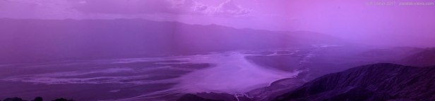
Combining the Schott UG11 filter with m BG40 filter, I can limit the light to just the ultraviolet range.
… yeah… that’s hazy. I can still see the other side of the valley, but I can’t distinguish anything from it. the only contrast is between the hills and the sky. Shadows? What are those?
My short pass filter(UV and violet light) had a problem. I made this filter myself from a filter not designed for a camera. It normally works fairly well, but there is a bit of discolouration around the edges of the photo. The problem comes because I’m stitching the photo together into a composite, and the edge isn’t the edge anymore. This is one of the few short pass photos that can be adjusted into a more neutral colour palate on the computer. Without adjusting the colour balance on the computer, it is somewhat noticeable…
But after I adjust it, it is really noticiable, with pink ‘smears’ around the edges.
Still, as expected, it is clearer than the full UV photo
On the longer wavelenths, however, the clearest photo is the only infrared one I took(with a Zomei 680 nm filter)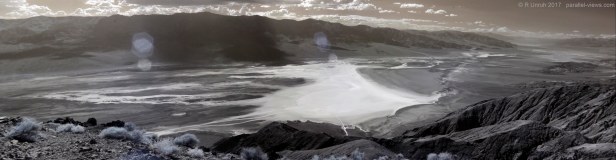
Ignoring the lens flare, everything is clear, from across the valley to the mountains in the far right of the photo. Because of the stress on my camera from the heat, and the stress on my me from the heat, I didn’t take any pictures with my other infrared filters.
Instead, I realized something. Like I said, only an idiot would camp at Furnace creek in that heat… which mean that if I did camp there, not only would I have the anecdote of sleeping below sea level, but I would have the whole campground to myself. I know what I wrote above, but would I really be an idiot to do this, or would I be outwitting the other tourists and finding a prime location for myself?
The next morning, I had my answer; it was the former.
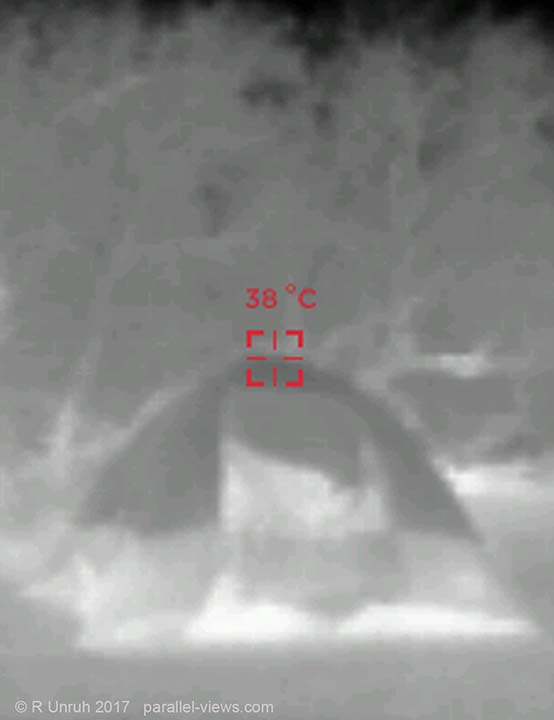
I blame the heat.
The above photos were taken with a modified Canon T3i Camera; the last thermal photo was taken with a Seek Reveal thermal camera.
